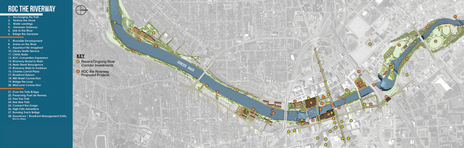
View the overview map with project legend below. Download a larger version of the overview map here>>

ROC the Riverway Primary Objectives
- Enhance the City’s potential for attracting State and private investment along the Genesee River;
- Produce seamless multi-modal access along both sides of the river via the Genesee Riverway Trail and neighborhood connections to the trail;
- Create dynamic public spaces, including a multi-use gathering space as the centerpiece of downtown;
- Provide a massive boost to downtown’s ongoing resurgence;
- Spur private development and job creation;
- Repair and maintain critical infrastructure;
- Remediate waterfront brownfield sites ;
- Increase boating activity in the water south of Douglass-Anthony Bridge (I-490);
- Establish a framework for active, sustained programming of public spaces and first floor uses.
ROC the Riverway Design Principles
- Focus on design that is oriented to pedestrians, bicyclists, boaters, and recreational enthusiasts;
- Re-orient buildings to the water and adjacent public spaces;
- Focus first on public spaces and facilities that serve citizens and visitors;
- Improve connectivity to, from, along and across the river;
- Create numerous opportunities for public art, historic interpretation, whimsical installations, and environmental stewardship – all united to create a sense of urban ‘play’ and celebration of the river.
Relationship to Other City Plans
ROC the Riverway projects have been identified in numerous other plans and studies. ROC the Riverway is a means to show how they can be stitched together to form a cohesive vision for a revitalized waterfront.
About the Renderings
All renderings shown above and in the document are conceptual, not final designs. All private development and privately-run activities illustrated are shown to demonstrate context and the potential for leveraging funding. All renderings provided by Bergmann Associates except Charles Carroll Plaza rendering provided by Olin / T.Y. Lin.
ROC the Riverway Projects
Aqueduct Re-Imagined and Riverfront
Promenade
The re-imagined aqueduct will be
the centerpiece of Downtown transformation – a place for public gatherings and
community events, an opportunity for informal and formal programming, and the
vital component in achieving the overall goal of the ROC the Riverway campaign
– bringing people to the water. Removal of the vehicular deck of the Broad
Street Bridge will open up the former aqueduct and subway bed to create a
dynamic public space while enabling the completion of the Genesee Riverway
Trail through Downtown – a critical north-south connection on both sides of the
river. Phase 1 funding will pay for design of the new aqueduct and the
connecting trail segments.
More information here.
Rundel Library North Terrace
Work on the North Terrace in
conjunction with the Aqueduct Re-Imagined project creates the opportunity for
inclusion of outdoor library rooms, cafe spaces, and enhanced programming
opportunities. It is designed to seamlessly integrate with any design
solution for the Aqueduct while connecting to the new riverfront
promenade spaces. The design will open up dramatic new views of the river and
rapids south of Court Street.
More information here.
Pont de Rennes Bridge
In addition to City and State
investment in the structural repairs, ROC the Riverway funds will be used to
create a more dynamic public space along the bridge with creative lighting,
public art, plantings, and trail connections to enhance the visitor experience.
The project will support planned investments at High Falls Terrace Park,
the Brewery Line Trail, Rochester Waterworks Building, and the continued expansion of North American Breweries
(Genesee Brewery).
More information here.
Rochester Riverside Convention Center South Terrace and Addition
Funding will expand the southwest
face of the Joseph A. Floreano Riverside Convention Center along the river to
create a dynamic venue space that directly engages with the downtown
waterfront. The current terrace, which is open to the public
as part of a larger riverfront promenade system, will eventually become part of
the Genesee Riverway Trail. The project would also include widening the south
end of the terrace and creating a cantilevered viewing and gathering space for
use by the Convention Center and residents alike. Public spaces would be
energized by new opportunities for public art, creative lighting, and even
pop-up retail.
More information here.
Blue Cross Arena
This project will build off of past
City and State investment to enhance the riverfront promenade and improve facility
access by creating an expansion of the arena's riverfront side.
The expansion will also include
enlarged concession areas on the second level to showcase the incredible river
view, providing an enhanced fan experience. The river terrace will be redefined
and enhanced to create an open and dynamic riverfront interface with activities
in and around the arena and adjacent Broad and Court Street connections. In
conjunction with the Aqueduct Re-Imagined and Riverfront Promenade project, it
will dramatically open up views and public spaces that will complement activity
at the arena. This includes providing a more visible public presence to the War
Memorial Flame at the river level of the building.
More information here.
Riverway
Main to Andrews
West: Charles Carroll Plaza & Sister Cities Bridge
East: Genesee Crossroads Park
The renovation of Charles Carroll
Plaza, the western riverfront link between Main Street and Andrews Street, will
reinvigorate this critical public space by improving access, safety,
connectivity and programming opportunities. Improvements will include improved
lighting, greenspace, and views of the river. It will create ADA accessible
connections between Main, Andrews, State, and St. Paul Streets as well as on the
Sister Cities Bridge. Numerous walls that block views and create the perception
of unsafe spaces will be removed. The riverfront experience on the east side,
while narrower, will also be enhanced as a standalone project distinct from the
west side. Collectively, these improvements will create a key site for various
programming activities put on by the proposed Downtown/Riverfront Management
Entity (see below), as well as an every-day riverfront park for downtown residents,
especially those in the adjacent Andrews Terrace.
More information on the Charles Carroll Plaza & Sister Cities Bridge here.
Genesee Gateway Park
The re-imagined park will create a
space which visually and physically connects the river to the surrounding
neighborhoods. Areas for respite, flexible uses, and everyday play will ensure
this is a riverfront park that offers something for all age ranges. The
redeveloped park will also provide critical access to the river for
non-motorized watercraft, as the next closest location to put in paddle boats
is 2.2 miles upriver at the Genesee Waterways Center. The enhanced park will
continue to host the South Wedge Farmers Market and will help entice
river-oriented mixed-use development at the City-owned site to the north.
More information here.
Corn Hill Navigation
Corn Hill Navigation is currently
engaged in a capital campaign to fund the purchase and operations of a downtown
boat. ROC the Riverway funding would go directly to that campaign, recognizing
the critical value of this educational and tourism asset in the South River
corridor. The boat is of particular value to the Rochester City School District
and other nearby schools, as an education curriculum has been developed to
introduce students to the river’s history, ecology, and opportunities for
environmental stewardship.
High Falls Terrace Park
Brewery Line Trail
St. Paul Street Underpass
High Falls Overlook Feasibility
Study
Building upon the 2015 High Falls
Pedestrian Access Improvement Study and the efforts of Greentopia in the area,
this ROC the Riverway project actually consists of three distinct projects
designed to address multiple needs in and near the park. For starters, the
trail along the gorge is narrow and fenced off, limiting access. A wider trail,
known as the Brewery Line Trail and part of the Genesee Riverway Trail system,
will be relocated along a recently acquired railroad right-of-way that
traverses the park, removing the need for the fence. Selective vegetation
clearing will open up better views of the falls. A more welcoming connection to
downtown will be established through better signage, lighting, and cosmetic
improvements to the St. Paul Street underpass of the CSX railroad bridge.
Various park amenities such as picnic tables and grills will be installed.
Lastly, a study will be conducted to examine the feasibility of creating public
access to the roof of the former RG&E Hydrostation #4 at the eastern edge
of the falls.
More information on the Brewery Line Trail here.
More information on the High Falls Overlook Feasibility Study here.
Running Track Bridge Stabilization
The Running Track Bridge is a
former rail bridge that once exemplified Rochester’s industrial prowess. Today,
the bridge sits abandoned but continues to highlight the importance of
connections across the Genesee River, linking neighborhoods like El Camino,
Edgerton, and High Falls as well as destinations on either side. Rehabilitating
the bridge as a pedestrian amenity will highlight the historic value of the
structure, and reuse of this resource will allow the City to meet today’s needs
and ensure complementary and cohesive connections to other ROC the Riverway
projects. Phase 1 funding will secure the structure of the bridge to enable a future conversion to a multiuse trail.
More information here.
ROC City Skate Park
The skate park, Phase I completed in Fall 2020, boasts multiple
features such as a main skate promenade, mini-ramps and ledges, and competition
bowls. It also has opportunities for public art, music performances, and
spectator seating. Located alongside the existing Genesee Riverway Trail and
with easy access from South Avenue, the skate park attracts wheeled enthusiasts and spectators. It capitalizes on land that was otherwise
unbuildable, situated under an interstate bridge and associated off ramps. This
benefits skate park users as there are elements that enjoy shade and
shelter while other elements are open to the air.
The skate park provides a much
needed boost of activity on the edge of Downtown and in the South River
Corridor. As was pointed out repeatedly during the ROC the Riverway public
process, skateboarding has an emerging reputation of breaking down racial and
socio-economic barriers in a way unlike any other sport. Design for Phases II and III of the Skate Park is set to begin in Fall 2021.
More information here.
Downtown / Riverfront Management
Entity
In order to achieve a more vibrant,
dynamic riverfront experience, a Downtown / Riverfront Management Entity will
be created that will program and maintain the existing and newly created public
spaces.
The City of Rochester and ROC the
Riverway Advisory Board have explored management entity models across the
nation, including Buffalo, Chattanooga, Baltimore, and Grand Rapids. While the
sustainable funding model, scope, and other details of Rochester’s management
entity are still to be determined, there has been strong community support for
pursuing additional programming and management opportunities for these spaces.
Management entities around the
country have a variety of responsibilities, including but not limited to:
community visioning and engagement; coordinating private development
activities; overseeing public infrastructure investments; receiving state and
philanthropic funding; developing and implementing programs and events;
engaging in marketing and branding efforts; maintenance and upkeep of public
spaces; proliferating public art; and recruiting businesses. Such an entity
will be critical to connecting people to the water and activating the great
public spaces being created through ROC the Riverway while continuing the
momentum of Downtown’s resurgence.
Front Street Promenade
Public investments along the water’s edge, including a formal pedestrian promenade, will allow future development to take advantage of this unique position along the Genesee, with direct connections to the Genesee Riverway Trail to the south. An attractive pedestrian connection along the water will extend west along the north end of the site, connecting to the Mill Street tunnel under the Inner Loop. Signage, plantings, and surface improvements along these edges of the site will be designed to attract private development.